
People
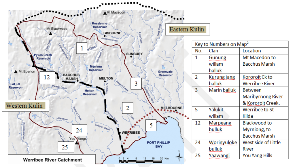
Key to Numbers on Map2
| No. | Clan | Location |
| 1 | Gunung willam balluk | Mt Macedon to Bacchus Marsh |
| 2 | Kurung jang balluk | Kororoit Ck to Werribee River |
| 3 | Marin balluk | Between Maribyrnong River & Kororoit Creek. |
| 5 | Yalukit willam | Werribee to St Kilda |
| 12 | Marpeang bulluk | Blackwood to Myrniong, to Bacchus Marsh |
| 24 | Worinyuloke bulluk | West side of Little River |
| 25 | Yaawangi | You Yang Hills |
In the above map of the Werribee River Catchment 1 as defined by the brown continuous line, all streams flow into the Werribee River or into Port Phillip Bay. For the three major language groups who lived in the Werribee River Catchment, the Werribee River was a major border. The superimposed dotted lines show where different groups and some of their clans lived.
The clans belonged to three language groups, Western Kulin Watha wurrung clans to the west of the river, and the Eastern Kulin Woi wurrung to the east but above the dotted brown line, and the Eastern Kulin Boon wurrung also to the east but below the dotted brown line. Each clan, usually up to some hundreds of people, lived a sustainable existence by hunting and gathering food when moving around their area or estate, and respected the estate of others. The exact borders between estates may have moved over time, but the dotted lines reflect the situation at the time of settlement by Europeans.2
The Watha wurrung clan were part of the Western Kulin nation, and spoke a language which shared fifty percent of a common vocabulary with the Woi wurrung and the Boon wurrung, part of the Eastern Kulin nation. The Woi wurrung and the Boon wurrung shared up to ninety three percent of a common vocabulary.2
The three language groups also shared Dreaming figures Bunjil (Eaglehawk) and Waa (Crow). Marriage and ceremonial bonds often connected the groups, as well as trade. For example, the Yalukit willam clan of the Eastern Kulin Nation lived in the narrow coastal strip below the brown dotted line from the Werribee River across to present day St Kilda, and had contact with the Watha wurrung clans of the Western Kulin.2
Other clans who lived in the catchment are named in the table accompanying the map.
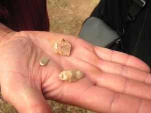
Stone artifacts found on Werribee River floodplain in Werribee Township
While evidence of the original inhabitants can be found in the catchment 3unfortunately today there is very little left of the language and culture of these people.
Presland 4 (2008, P.204) notes that there is a broad correlation between language group estates and drainage basins. The Werribee River Association has a great interest in the need for integrated catchment management, and could say that these original inhabitants were the first catchment managers.
References:
1 Department of Primary Industries Research Victoria
2 Presland, G. ‘First people: The Eastern Kulin of Melbourne, Port Phillip and Central Victoria’ Museum Victoria 2010
3 Werribee River Willow Removal – Cultural Heritage Assessment – Preliminary summary – Cultural Heritage Survey December 2004 by Andrea Murphy & Lucy Amorosi, Tardis Enterprises Pty Ltd
4 Presland, G. ‘The Place for a Village; How nature has shaped the City of Melbourne’ Museum Victoria 2008